

CARTERVILLE Ill. (WSIL) -- Snow is beginning to fall across the area. Once it starts it won't be stopping until early tomorrow morning. Bands of moderate to heavy snow will accompany the snow this evening. Driving will be near impossible as snow will be efficiently sticking due to temperatures being in the teens and low 20s.
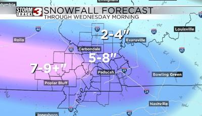
We are still looking at 5-8 inches of snowfall area-wide with higher totals locally wherever mesoscale banding develops. All in all, this will be a significant snowstorm for the region. This will be a very dry and powdery snow which will blow around very easily. Expect snowfall drifts where wind drives snow consistently on buildings and roadways. Visibilities will also be very low as the snow is falling across the area.
Best to hunker down and stay inside while the snow falls. Travel will remain difficult through Wednesday as the snow won't be going anywhere with mostly cloudy skies and temperatures staying in the teens. The other big story will be the cold. Cold weather advisories are already out for Wednesday night into Thursday morning where wind chills could get down to -10 and -15 degrees.