CARTERVILLE, Ill. (WSIL) -- Rain will be with us throughout this weekend with the potential for strong storms developing on Sunday.
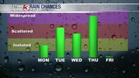
Rain chances for today will be scattered to widespread. Widespread rain will be with us though most of the day and will likely not wind down until after 6 or 7 in the evening. There could be a lull in the shower activity overnight through Sunday morning. Sunday is definitely a day to remain weather aware.
The entire region is in an enhanced level 3 out of 5 severe weather risk for Sunday afternoon. We are monitoring the potential for strong to severe storms to form between 4 p.m. and 2 a.m. We expect supercell thunderstorms to form in the afternoon and evening, with the primary hazards being extremely large hail and tornadoes. One thing that may end up being a limiting factor for these supercells will be a strong cap in the atmosphere.
We expect the cap to break down as we head into the late evening. This will be associated with a cold front, and along it, we expect a line of storms form and track through the region. Damaging winds and a few tornadoes are possible with the line.
Temperatures will remain fairly constant through the day on Saturday. Sunday will be much warmer, with highs expected to be in the upper 70s, perhaps even warmer if we can get more sunshine.