

CARTERVILLE, Ill. (WSIL) -- Storms have entered our region and will continue tracking east throughout the evening hours.
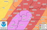
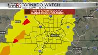
A portion of the area was earlier upgraded to a High Level 5 out of 5 risk of severe weather, meaning confidence has increased even more in which we will see widespread and potentially significant severe weather.


The high risk area for severe weather stretches to parts of southeast Missouri, western Kentucky, southern Illinois and northwest Tennessee.

As of 4:30 p.m. the severe weather has entered southeast Missouri and is tracking more into our region, bringing with it the potential for large to very large hail, potentially long-lived strong tornadoes and widespread damaging winds.


Timing:
Timing on this looks to run, broadly, between 4 p.m. and 11 p.m. today. Storms should first fire in southeastern Missouri around the 4 o’clock hour, and rapidly intensify. Better wind shear will push into the region in the early evening hours, leading to more intensification for storms.

Specifically for southern Illinois, storms should remain to our west until 4:45 p.m. where it will first move into Randolph County. As the storms cross the Mississippi River, they are anticipated to intensify posing a risk of large hail, damaging winds, and tornadoes, some of which could be on the strong side. East of Interstate 57, I am most concerned with the potential for several tornadoes, some potentially stronger, as well as, the previously mentioned damaging wind and hail threats. Storms should exit some time after 9-10 p.m. in the evening, in southern Illinois, but we could see storms linger across western Kentucky through midnight.


PADUCAH, Ky. -- Anytime there are storms in the forecast, it's better to prepare in case something were to happen.
We are likely to see significant impacts from severe weather that has the potential to be as impactful as Friday, March 14th.
Depending on how fast the storms get out of here on Wednesday night/Thursday morning, we may have to watch for additional severe weather on Thursday as well, but the risk is much lower, only a 2 out of 5.
There is also a flood watch for our entire coverage area, with the exception of Madison County, Missouri and Randolph County, Illinois.
There is widespread and dangerous flooding expected with this stalled system, with the potential of 10-15 inches of accumulated rainfall at any given place in our area starting on Wednesday and running through Saturday night. Flash flooding concerns will be ongoing starting on Wednesday through Saturday night with more concern on Saturday as flash flooding could be potentially catastrophic.
Excessive rainfall outlook is high (level 4 of 4).