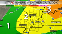


CARTERVILLE, Ill. -- This morning, we are keeping a close eye on a line of strong to severe thunderstorms that are tracking west to east across much of the area. We also have a tornado watch that is in effect until 8AM for some of our southeastern Missouri counties.
As we go throughout the rest of the day, we will see storms this morning push out of the area by midmorning, and we should only see isolated showers by lunchtime.
Storms will return to the area this afternoon and evening, mainly after 3PM and they could be on the strong to severe side, especially in our eastern most counties. Any storms that do develop this afternoon could be capable of producing damaging winds, large hail, and a brief tornado. These storms will exit the area this late this evening and lead to some calm conditions for the overnight hours.

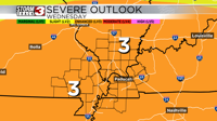
We will see a lot of sunshine tomorrow morning, which will help destabilize the atmosphere. We will see widespread showers and storms start to develop tomorrow early in the afternoon and these storms will be capable of producing all hazards including the potential for large hail (2 inch in diameter or greater), a few tornadoes (some could be on the stronger side), and damaging winds (possibly as high as 70 miles per hour). We will see storms last through most of the evening and early overnight hours. For these storms, there is already a level 3 risk of severe weather for all of us.
We are closely monitoring the chance of a significant severe weather event for tomorrow.