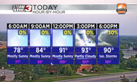

WSIL(Carterville, Ill.)-- This morning, a lot of us are waking up to temperatures that are in the upper 70s and even lowers 80s. Earlier, we saw a few showers and storms, but things are currently dry and mostly clear.
Today, you can expect to see very hot conditions with air temperatures in the mid 90s, and heat index between 105 and 110.
For most of us, there is a heat advisory in place from 11AM today through 8PM Wednesday. Through the middle of the region, including the cities of Carbondale and Marion, there is an Excessive Heat Warning in place also from 11AM today through 8PM Wednesday for heat index values that could be as high as 115 degrees.
In addition to the the heat, we are also tracking the potential for showers and storms later. For most of the afternoon, we should be dry and mostly sunny. But, after 4PM this afternoon, we could see a few isolated showers and storms.
Later this evening, and into the early overnight hours, we will see a line of showers and storms track from northwest to southeast. There is some disagreement with where the line sets up and tracks, but the ingredients are certainly present. This line could produce damaging winds as well as some small hail and a brief spin up tornado can't be ruled out.
That's why there is is a level 2 risk of severe weather for most of the region later this afternoon and evening.
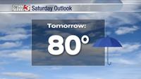
The excessive heat warning does last until tomorrow evening, so you can expect to see sweltering temperatures to return to the region. Highs should be similar to what we will see today.
We will also see isolated shower chances tomorrow afternoon.