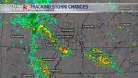


PADUCAH, Ky. (WSIL) -- A Severe Thunderstorm Watch has been issued for a portion of western Kentucky and northwest Tennessee on Thursday.
The National Weather Service issued the watch in effect until 8 p.m. on May 8.
There are some storm threats weather officials stated in which are of concern. This includes scattered hail up to two inches, scattered wind gusts up to 70 mph and frequent lightning is possible.
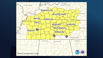
The Severe Thunderstorm Watch also extends into south-central Kentucky and into the Nashville area in Tennessee.
Here are the counties included in the watch in the WSIL viewing area...
Kentucky
- Carlisle
- Fulton
- Graves
- Hickman
- Calloway
- Marshall
- Lyon
- Caldwell
Tennessee
- Obion
- Weakley