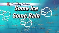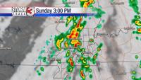
(CARTERVILLE) WSIL -- Sunday is another good day to be weather aware as a passing cold front may bring severe weather to the region.
The Storm Track 3 weather team is tracking a system that is bringing showers and a few rumbles of thunder through the area this morning. That same system will bring a line of thunderstorms later on this afternoon. Our main risk with this line will be strong winds, but a brief spin up tornado can not be ruled out with this afternoon's storms.
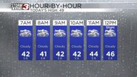
Today will be warm and humid with highs this afternoon reaching mid to upper 70s. Cooler weather will return tomorrow, as a cold front drops highs for Monday into the 60s.
Meteorologist Jacie Brianne will be back tonight with an update to your forecast.