WSIL -- The rain has ended! A very soggy end to the weekend left low-lying areas inundated with water, but a cold front has swept through the area and pushed the rain to the east.
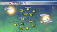
Winds are back out of the north and temperatures have reacted, dropping back into the 30s and lower 40s.
Skies are expected to gradually clear this morning from the west, and many of us can now begin to dry out.
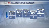
Despite the sun, afternoon temperatures will stay on the cool side, with highs only in the upper 40s and lower 50s.
Another small chance for a few showers arrives Tuesday afternoon, mainly focused near the Kentucky/Tennessee line.
Meteorologist Nick Hausen has the latest on what to expect for the upcoming week! Join him on News 3 This Morning!