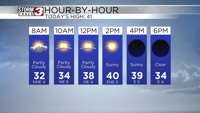


CARTERVILLE, Il. (WSIL) -- It was another typical summer afternoon. Spotty showers and thunderstorms have popped up again across the region. Brief heavy rainfall and lightning are the main hazards. Storm activity should start to diminish after sunset.
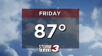
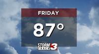
Similar conditions are expected Friday. High temperatures will stay close to average, topping out in the mid to upper 80s. The humidity will stay relatively high, definitely feeling like summer. Much like the past couple of days, storm chances will stick around. The best chance for storms will continue to be during peak heating hours, the afternoon and evening.
The weekend will bring slightly higher storm chances, but they will still be scattered in nature. There will be plenty of dry time. High temperatures will remain in the mid to upper 80s.
By next week the heat will begin to crank it up a notch. High temperatures will rise back into the low 90s, accompanied by triple digit heat indices.