


WSIL (Carterville) -- A wet day across the region as showers and storms move through this afternoon. Severe Thunderstorm Warnings have so far stayed out of our region, but the threat for localized flooding and lightning is still there.

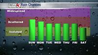
Now that the rain has started, we'll have a hard time shaking it. Expect scattered shower and storm chances to continue into this evening and tonight. Temperatures remain fairly mild with highs reaching 80 degrees.

Overnight we'll dip into the mid to upper 60s. Tomorrow looks to be very similar to today in terms of rain chances and temperatures.

Make sure if you have any outdoor events this weekend, that you have a backup plan indoors just incase. This shouldn't be a complete washout, but scattered to numerous showers and storms could ruin some outdoor activities.

Between now and Monday night, some of us could pick up a few inches of rain. It's important to be weather aware this weekend because localized flooding associated with heavy pockets of rain will be an issue.

You'll want to keep the umbrella around after your three day weekend as the rain chances persist into the work week.