Here is video from Cody Hutchinson of a tornado spotted south of Marion, Illinois.
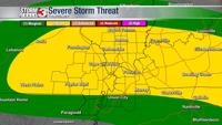
MARION, Ill. (WSIL) -- A total of nine tornadoes hit the region on May 16, with some carving a path of destruction and destroying homes along the way. Some of the tornadoes are also responsible for killing two people and injuring more than a dozen.
Here's the breakdown of all tornadoes which hit our region on May 16, according to the National Weather Service.
May 16 - Blodgett, Missouri
- Time: 3:54 p.m. - 4:15 p.m.
- EF Scale: EF3
- Est. Peak Winds: 152 mph
- Track Length: 16.4 miles
- Max Width: 200 yards
- Injuries/Deaths: 10/2
Summary: A 16 mile long EF3 tornado started in eastern Stoddard County along County Highway Y, approximately 5 miles southeast of Bell City. It removed a roof of a house shortly after touching down and then continued east into Scott County. As it crossed Highway 61 it damaged approximately 10 power poles. The worst damage was found in the Sloanville Drive area where numerous homes were heavily damaged or completely destroyed, this included a brick home and several mobile homes. Two fatalities occurred along this road. Numerous more homes were either significantly damaged or completely destroyed from just west of I-55 and continuing east to Woodhaven Estates. Dozens of trees were snapped or uprooted. Many outbuildings suffered some degree of damage or were a complete loss. Max width was 200 yards. The tornado lifted just east of Highway O about 3 miles west of Diehlstadt. There were 10 injuries with this tornado as well.
May 16 - Burfordville, Missouri
- Time: 4:03 p.m. - 4:05 p.m.
- EF Scale: EF2
- Est. Peak Winds: 125 mph
- Track Length: 1.4 miles
- Max Width: Missing
- Injuries/Deaths: 0/0
Summary: An EF2 tornado touched down about 1.5 miles east of Burfordville in Cape Girardeau County. It tracked east for about 1.4 miles before lifting 3 miles east of Burfordville. The worst damage occurred along County Highway 363 where a home suffered significant roof damage. Further east along County Highway 343 there was an outbuilding with significant damage along with a mobile home that had minor damage. Several trees were uprooted along the path as well. Max width was 100 yards.
May 16 - Marion, IL
- Time: 6:15 p.m. - 6:32 p.m.
- EF Scale: EF4
- Est. Peak Winds: 190 mph
- Track Length: 16.6 miles
- Max Width: 575 yards
- Injuries/Deaths: 7/0
Summary: A violent EF-4 tornado with peak winds of 190 mph impacted southern Williamson County, IL, during the early evening hours of Friday, May 16, 2025. The tornado began near the intersection of Spillway Road and Grassy Road doing mainly tree damage. As it moved eastward, the tornado intensified as it approached Interstate 57. The tornado strengthened to EF-3 levels, where it removed the roofs of several homes of the staff of the U.S. Penitentiary just south of the main prison complex. The tornado debarked and reduced to stubs numerous trees adjacent to Interstate 57. The tornado continued at EF-3 strength as it damaged homes along Highway 37 and north of Hudgens Road. The tornado reached peak intensity after crossing Market Road and into a subdivision just east of Andrew Road and north of Quarter Horse Road. Four homes on Kyler Court and Leslie Court sustained EF-3 damage. In addition, a newer two-story home with standard construction was completely swept off its foundation at the end of Kyler Court, which supported a rating of EF-4 with peak winds of 190 mph. The wooded area just east of Kyler Court saw extreme stubbing and some debarking of trees. The tornado continued eastward, destroying or severely damaging several homes at EF-2 or EF-3 strength on Wards Mill Road. Additional homes were destroyed at EF-3 damage levels a couple miles to the east on Highway 166. After crossing Highway 166, the tornado turned to the east-southeast and began to weaken, eventually lifting near the intersection of Mauseyville Road and Tyler Bridge Road. The tornado path was 16.57 miles, and its peak width was 575 yards. There were no fatalities, but seven people sustained non-life-threatening injuries.
May 16 - Morley, Missouri
- Time: 6:40 - 6:42 PM
- EF Scale: EF1
- Est. Peak Winds: 110 mph
- Track Length: 1.3 miles
- Max Width: 100 yards
- Injuries/Deaths: 0/0
Summary: An EF1 tornado touched down approximately 2.5 miles south of Benton in northern Scott County. It was on the ground for 1.3 miles before lifting just west of I-55 about 3.5 miles southeast of Benton. Total destruction of a detached garage/barn occurred along Highway 403. Several trees were snapped or uprooted along with a few other farm buildings being damaged. Max width was 100 yards.
May 16 - Allegre, KY
- Time: 6:42 - 6:49 PM
- EF Scale: EF2
- Est. Peak Winds: 120 mph
- Track Length: 6.0 miles
- Max Width: 200 yards
- Injuries/Deaths: 0/0
Summary: An EF2 tornado started along Shaw Ovil Road where it did some minor damage to a couple homes. It continued east into Todd County crossing Hwy 189 and eventually lifting to the west of Hwy 181. The worst damage occurred along Blue Hole Road where several chicken houses were completely destroyed and a mobile home was swept away. Dozens of trees were snapped or uprooted and a few outbuildings were damaged. Max width was 200 yards and peak winds were 120 mph.
May 16 - Mitchellsville, IL
- Time: 6:48 - 6:54 PM
- EF Scale: EF1
- Est. Peak Winds: 88 mph
- Track Length: 6.8 miles
- Max Width: 75 yards
- Injuries/Deaths: 0/0
Summary: An EF-1 tornado damaged trees in a 6.78 mile long path across southeast Saline County, Illinois. No structural damage was reported. Estimated peak winds were 88 mph.
May 16 - Leamington, IL
- Time: 6:56 - 7:05 PM
- EF Scale: EF2
- Est. Peak Winds: 115 mph
- Track Length: 10.0 miles
- Max Width: 250 yards
- Injuries/Deaths: 0/0
Summary: An EF-2 tornado began in far southeast Saline County and then crossed into southern Gallatin County along a 10 mile path. The most severe damage occurred near the start of the path along Gape Hollow Road, Forest Road, and Barrett Cemetery Roads, where several trees were snapped and wooden power poles were broken. The tornado then weaken to EF-0 intensity as it moved east across Highway 1 near the Gibsonia community. The tornado lifted shy of of the Ohio River at Jester Road.
May 16 - Morganfield, KY
- Time: 7:16 - 7:29 PM
- EF Scale: EF3
- Est. Peak Winds: 155 mph
- Track Length: 9.9 miles
- Max Width: 500 yards
- Injuries/Deaths: 4/0
Summary: An EF-3 tornado with peak winds of 155 mph impacted the south side of Morganfield, KY, on the evening of May 16, 2025. The tornado began along Bunger Road where ground scouring of newly-planted crops was seen. Moving east, the tornado intensified, doing EF-3 damage to several homes on Highway 130, Robinson Road, US Highway 60, Terre Hill Road, and Wildlife Road. Some homes suffered near catastrophic damage, with most roofs and most exterior walls removed. The tornado weakened after it crossed Highway 56 moving east, lifting near Kit Harris Road. The tornado reached a peak width of around 500 yards and caused four minor injuries along its 9.94 miles track.
May 16 - Casky, KY
- Time: 9:26 - 9:34 PM
- EF Scale: EF2
- Est. Peak Winds: 118 mph
- Track Length: 10.1 miles
- Max Width: 225 yards
- Injuries/Deaths: 0/0
Summary: An EF2 tornado touched down along County Highway 164 just north of I-24 and caused some shingle damage to a house and pretty significant damage to a couple of barns. It continued east uprooting or snapping dozens of trees along its path. Many homes experienced mainly roof damage along River Bend Road and Westminster Place. The tornado crossed alt 41 and snapped about a half dozen power poles. Some damage to a house and outbuildings occurred along Harry Berry Lane before the tornado lifted just east of County Highway 109. Max width was approximately 225 yards with peak winds of 118 mph. The tornado occurred within a broader area of sporadic straight line winds that swept across southern Christian County.