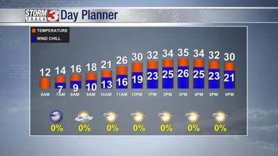


WSIL (Carterville, IL) -- Saturday morning temperatures were in the single digits to the north and seeing 10's to teens to the southern portion of the viewing area.
The morning and afternoon will make way for sun, but it is looking to be a chilly and breezy day.
Saturday's highs are forecast to be into the mid 30's with an overnight low into the upper 20's.
Sunday's highs are forecast to be in the lower 40's with an overnight low into the upper 20's.
Passing clouds will be probable throughout the day.
Monday is forecast to be the best day to get outside - it will be the warmest and most dry day of the work week.
Monday's forecast highs are expected to be in the lower 50's to the northern half of the viewing area, and into the mid to upper 50's for the southwestern parts.
Overnight lows are forecast to be in the lower 40's.
A few clouds will be moving through ahead of the next system.
By the later half of the work week, we are keeping an eye on a possible rain to snow maker.