

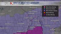


WSIL -- A Winter Weather Advisory will go into effect again for much of southern Illinois, southeast Missouri, and western Kentucky at 3 p.m. Monday and go until 9 a.m. Tuesday.

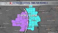
The next round of light winter weather will move in later this afternoon, likely around the time school is letting out in southeast Missouri. For Illinois and Kentucky, arrival will be closer to sunset.

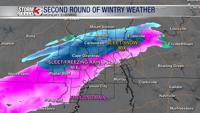
Temperatures will be considerably colder with this round, so the precipitation type is expected to be mostly sleet across much of Missouri and Illinois. A little snow could also mix in, especially north of Route 13 in Illinois. Farther south, freezing rain will be more likely, especially in the Missouri Bootheel and near the Kentucky/Tennessee state line.
Sleet will start to wrap up around midnight, but freezing drizzle will remain possible overnight and into early Tuesday morning. While amounts will be on the lighter side, even small amounts of ice can lead to very slick and dangerous travel. Roads could become very icy tonight.
By daybreak Tuesday, another lull in winter weather is expected, but cold temperatures may keep icy conditions around much of the day.
Another wave of light freezing rain is possible Tuesday evening, mainly along and south of Highway 60 in Missouri and near the Kentucky/Tennessee line. Chances for winter weather Tuesday evening are much lower in southern Illinois.