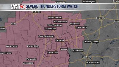


WSIL -- A Severe Thunderstorm Watch has been issued for the entire Storm Track 3 viewing area until 9 p.m. on Saturday.
Storms will gradually increase across southeast Missouri and southwest Illinois around 2-3 p.m. Saturday afternoon. Theses storms will track eastward into southern Illinois through late afternoon and early evening.
Some storms will likely be strong to even severe with large hail and damaging winds. The tornado threat remains low, but a brief spin-up tornado can not be entirely ruled out.
With this being a holiday weekend, those who have plans to be outside including camping and boating need to be extra weather aware and have a way to receive warnings and a place to take cover. A camper is not a safe place to ride out a severe thunderstorm.
The Storm Track 3 team has you covered and will be providing updates throughout the afternoon.