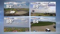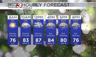
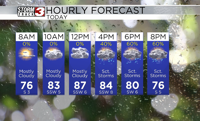


WSIL(Carterville, Ill)-- This morning, most of us are waking up to temperatures in the lower 70s and upper 60s with partly cloudy skies.
As we go throughout the day we will see temperatures warm into the upper 80s and lower 90s for afternoon highs, and heat index values could be in the mid 90s thanks to tropical moisture.
This tropical moisture is associated with Hurricane Beryl, which will impact us starting late this evening.
Through the morning hours, we will be mostly dry, with only a few light spotty showers possible. With the heating of the day, however, we could see scattered showers and thunderstorms form in western counties in southeastern Missouri. These showers and storms will become more scattered by the time we make it to the evening, after about 6PM.
There is a low end risk that a few of these could be on the strong to severe side with the primary hazard being damaging wind. But, a brief tornado cannot be entirely ruled out.
Overnight tonight, we will see the outer bands of hurricane Beryl begin to impact the region.
Widespread rain and storms are expected as we start the morning hours tomorrow, and rain will last through the entire day. At times, rain could be heavy, so there is a risk of flash flooding. For this reason, there is flood watch in effect from late today through Wednesday morning. Broadly, 2-4 inches of rain is likely area wide. But locally higher amounts are possible.
In addition to the flooding threat, there is also a low end risk of severe weather. The main hazards with any storms will be damaging winds and a few brief tornadoes. This risk will be dependent on the track of the center of Beryl, but for now, the greatest liekyhood of severe weather is in our eastern counties.
Rain will last trough early Wednesday morning. Once rain chances end, we should be mostly dry through the end of the work week other than a few isolated storms on Thursday.