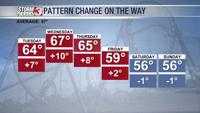
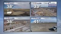
Carterville (WSIL) -- A much colder day on tap than what we are used to. Temperatures starting in the upper 20s for most of us, which is almost 20 degrees colder than we were 24 hours ago. We will barely see them recover into the low 40s if you're lucky to see the sun today.
I expect some clouds to develop across southern Illinois and western Kentucky potentially staying away from places in and around the boot heel of Missouri. Areas that see more sun today have the chance to get much warmer than areas that see more clouds.
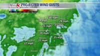
We will have one more harsh freeze tonight with temperatures for many of us dropping back into the 20s before recovering nicely into the 60s on a mostly sunny day for Tuesday. I expect winds to also pick up a bit for Tuesday with winds of 20 mph and gusts up around 30 mph. This combined with the dry airmass over our region poses a risk for fire weather danger so make sure you don't light any type of fires or throw any cigarettes out of car windows through the next couple days.