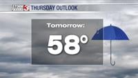
Carterville Ill. (WSIL) -- Another hot day today with temperatures climbing back into the mid and even upper 80s for some! We will be experiencing some of the hottest days of the year over the next couple so be wary of that if you have those outdoor plans! Tomorrow I am expecting some of our first 90 degree highs for our area so a good hint that summer is indeed on our doorstep.

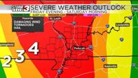
We stay dry for the next couple days but very late Tuesday night into Wednesday morning I expect a line of showers and some storms to roll through most of our area. Some storms could be on the stronger side with damaging wind gusts being the primary threat. Wednesday afternoon we see the opportunity to see more storms across the area and these have a better potential to become severe with damaging wind gusts and hail being the primary threats. We do have some favorable low level shear to introduce some tornado potential but there's a chance with the morning convection blending in with the afternoon convections that ingredients remain somewhat lackluster for widespread threat for tornados and severe. We will watch it closely as we get closer.
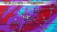
After Wednesday, we will see the front stall out over our region and there for could be a focus for multiple rounds of showers and thunderstorms through the weekend for our area. Everyday we see more rain means an increased potential for flash flooding on the day that follows so we will have to monitor that flooding potential closely as we progress through the week.