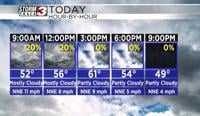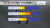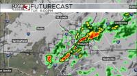


Carterville (WSIL) -- Another really warm day today after morning showers and thunderstorms. Temperatures rose into the mid and upper 70s across the entire area. Since the outflow from the earlier storms has left a boundary across our region we do expect more storms to fire along it this evening. Some hail could be possible in these storms just like in yesterdays storms but widespread severe weather is not expected today.
We will dry out on Wednesday but the clouds will remain for most of us. This will be out ahead of another storm system moving in for Thursday through Saturday. Severe weather does not look likely with this event either but a good rain maker for our region is most likely. Highs for the remainder of the week will stay in the mid 60s with this unsettled pattern.
Unfortunately, we wont see the sun a ton until we get to early next week. Expect a general cool down for your weekend with temps returning into the low 50s for high temperatures.