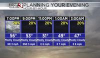


Carterville (WSIL) -- Temperatures soared into the low 60s today across the entire viewing area. Lows tonight not expected to get much lower than 40 degrees across much of the region. We should stay clear of clouds throughout the night tonight.
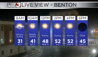
Tomorrow clouds should begin filtering in through the area and that should allow a mostly cloudy day ahead of our next weather maker on Thursday. Expect temperatures still to remain in the 60s with the chance we make it to near 70 in some locations. We may be cloudy but the southerly wind is going to help pump in some much warmer air from the south.

Thursday morning we should wake up to some isolated to scattered showers across the region. These should increase in coverage as we get to around 12-3 PM in the afternoon. I don't expect much in the way of severe weather due to the time of day these move through but we will watch the potential as we are still a couple days out.
We cool down a bit behind the system with temps in the mid 50s to start your weekend before another warm up early next week.