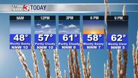

CARTERVILLE Ill. (WSIL) -- It was a dreary Wednesday. The light showers, drizzle and fog will stick around overnight. Allow yourself a little extra time if you have to get out. Visibility will be limited at times. Temperatures will warm as a boundary moves in from the south. High temperatures for many will occur during the early morning hours.

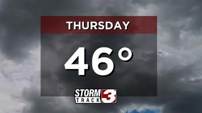
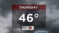
Thursday will be a mild start with temperatures in the low 50s, however our boundary will sink back to the south through the day. This will drop temperatures back into the 40s for areas north of the front.
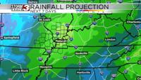
Off and on rain chances will stick around Thursday. It won't be a washout, some dry time will be mixed in. That rain should begin to lighten up Friday. Isolated showers are possible but the better chance for rain holds off until Saturday.
On Saturday a cold front will move through the region. This ramps up the chance for rain and even a few thunderstorms. Behind the front, a more winter-like airmass returns.