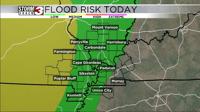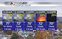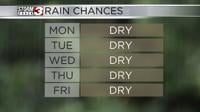


Carterville Ill. (WSIL) -- After today we should get rid of the afternoon rainfall chances as the remnants of Francine falls apart and moves west. We will however keep some of the pesky high cloud cover across the area through the day tomorrow. Expecting a mostly dry day for Monday with our temperatures for everyone in the upper 80s.

Throughout the next week we will see our temperatures increasing into the mid and upper 80s for many days. We will also see the clouds part with mainly sunny skies returning mid week. While our temperatures remain above average high pressure anchors over us and keeps our dewpoints in the 50s. This will allow humidity to stay in check leading to comfortable afternoons and nice evenings. Unfortunately, while the weather will seem nice, were entering another long stretch of dry weather across our area that is being plagued by widespread moderate drought. Even severe drought starting to crop up across western Kentucky. We need RAIN!