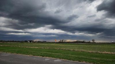


CARTERVILLE, Ill. (WSIL) -- A line of storms has now moved through the region, however, there are some lingering thunderstorms and heavy rain still. The storms earlier today brought lots of high winds, hail, rain and some tornadoes.


The entire region had an enhanced level 3 out of 5 severe weather risk for Sunday afternoon and into the evening hours. The storms were exiting the region by the 9 to 10 p.m. range.
The tornado watches were dropped after the main line of storms swept through the region.


Weather reports of large hail with some tree damage and some structural damage were reported.
Power outages were also an issue as hundreds were out, hitting Alexander County the hardest with more than 700 out by 8:30 p.m.
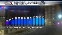
Temps are also dropping into the mid 50s at the end of the night.