
January 7th Evening Weather with Meteorologist Jacie Brianne
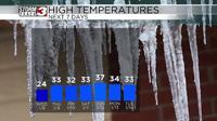
CARTERVILLE Ill. (WSIL) -- The winter weather is here to stay. Dangerous cold will stick around overnight and into Wednesday. Overnight low temperatures will dip into the single digits and teens. With temperatures dropping, refreezing and black ice will be continue to be a concern. Drive carefully.

Clouds will try to break up throughout the day Wednesday. The more sunshine we receive, the better. Sunshine would help melt some of the ice from trees and powerlines. However, it will still be very cold, highs will top out in the low to mid 20s.
Temperatures Thursday morning will potentially be the coldest temperatures of the week. Lows will dip into the single digits to start the day, but the afternoon will begin to warm slightly. Highs will rise back up near freezing, topping out in the low 30s.
Our next system is still set to arrive late Thursday night and through Friday. The focus or highest impacts are currently forecast for our far southern counties. A Winter Storm Watch is in place for Dunklin, Pemiscot, Lake, Obion and Weakley Counties.
We're still a few days away, but a couple of inches of additional snow is possible. The key word being snow, no ice is expected at this point.